Tornado Formation
There are various weather conditions that contribute to the formation of tornadoes. However, determining which weather conditions are most conducive to the formation of a tornado is more complicated than it appears. Strong tornadoes often begin during supercell thunderstorms, but it is difficult to distinguish which weather conditions will result in a tornado and which are more likely to cause other large storms (Edwards, 2011).
Among the indicators of typical weather conditions that cause tornadoes (as well as other severe storms) is the confluence of warm, moist air masses with cooler, drier ones. The cold air forces the warm air higher into the atmosphere where water vapor condenses and forms large cumulonimbus clouds (Gray, 2010). Once these clouds have formed, the occurrence of wind shear can set part of the cloud system rotating. A rotating cloud system is a strong indicator that a tornado may be forming (Dowsell, 2005).
Because it is a point of convergence for many different air masses, the area in the United States called "tornado alley" frequently experiences conditions that are conducive to tornadoes (Figure 1). Cumulonimbus clouds form as warm and humid air from the Gulf of Mexico meets cold, dry air from Canada. Fast-moving air currents called jet streams cause many of these cloud systems to begin rotating, making this region of the United States more tornado-prone than any other region in the world (Edwards, 2011).
Hail is another weather condition that can be associated with tornadoes, because both require updrafts to develop. Usually the hail storm may be a sign that a tornado is on the way (“Tornado: Development and Detection”, n.d).
Although the formation of tornadoes is not fully understood, it is known that typically a cumulonimbus cloud is needed. There are two main ways in which tornadoes form, and their method of formation determines the relative intensity of the storm. Oftentimes sizeable tornadoes, like the one that struck Joplin, MO, are formed out of supercells, which are “highly organized thunderstorms” that contain one very strong updraft (Figures 2 and 3). Supercells are unique compared to other types of thunderstorms in the fact that they also rotate. This rotation is known as a mesocyclone and is responsible for producing several types of severe weather, including strong tornadoes (Doswell, 2005). A tornado is formed when a downdraft is introduced and forces the rotation down. This downdraft is called the rear-flank downdraft, and it descends to the surface nearly the same time as the tornado circulation (Figure 4). It is believed the descent is caused by “rapidly lowering barometric pressure near the ground,” although this is not known with complete certainty (Doswell, 2005).
The other way in which tornadoes form is when there is “a change in wind direction and an increase in wind speed with increasing height [and it] creates an invisible, horizontal spinning effect in the lower atmosphere” (“Tornadoes: Natures Most Violent Storms”, 2011). If this is to happen during a thunderstorm, the updrafts can become powerful enough to lift the horizontal spinning effect vertically. The tornadoes formed in this way are less severe and more common (“Tornadoes: Natures Most Violent Storms”, 2011).
Once the tornado reaches the ground, it moves in the direction of the cumulonimbus cloud (Fabian, n.d). The tornado is perpetuated by an inflow of warm, moist air, as well as the rotation of air masses (Edwards, 2011). The tornado may appear transparent or white at first, but after picking up debris, it begins to look darker (Fabian, n.d).
Typically within a matter of minutes after the tornado reaches the surface, the rear-flank downdraft touches the ground and begins to encircle the tornado. As this occurs, the inflow of air becomes interrupted. Once the rear-flank downdraft encases the entire tornado, the inflow is fully cut off. This weakens the tornado (Edwards, 2011), and it steadily decreases in intensity and size. The tornado then tilts and takes the shape of a thin, distorted line before completely dissipating (Doswell, 2011)
Tornadoes may last anywhere from less than a minute to over an hour. The majorities are weaker and consist of 69 percent of all tornadoes. They are categorized as having wind speeds less than 110 mph and last an average of one to ten minutes. Strong tornadoes include 29 percent of all tornadoes, have wind speeds of 110-205 mph, and may last 20 minutes or more. Only two percent of tornadoes are violent tornadoes, which have wind speeds greater than 205 mph and may last longer than an hour. Tornadoes can occur at any time of the year. In the southern states, the majority occur between March and May, whereas in the northern states, tornadoes mostly occur during the summer months (“Tornadoes: Natures Most Violent Storms”, 2011).
Page created by the "Tornado Research Group" at Illinois State University, Geology 207 Honors Section
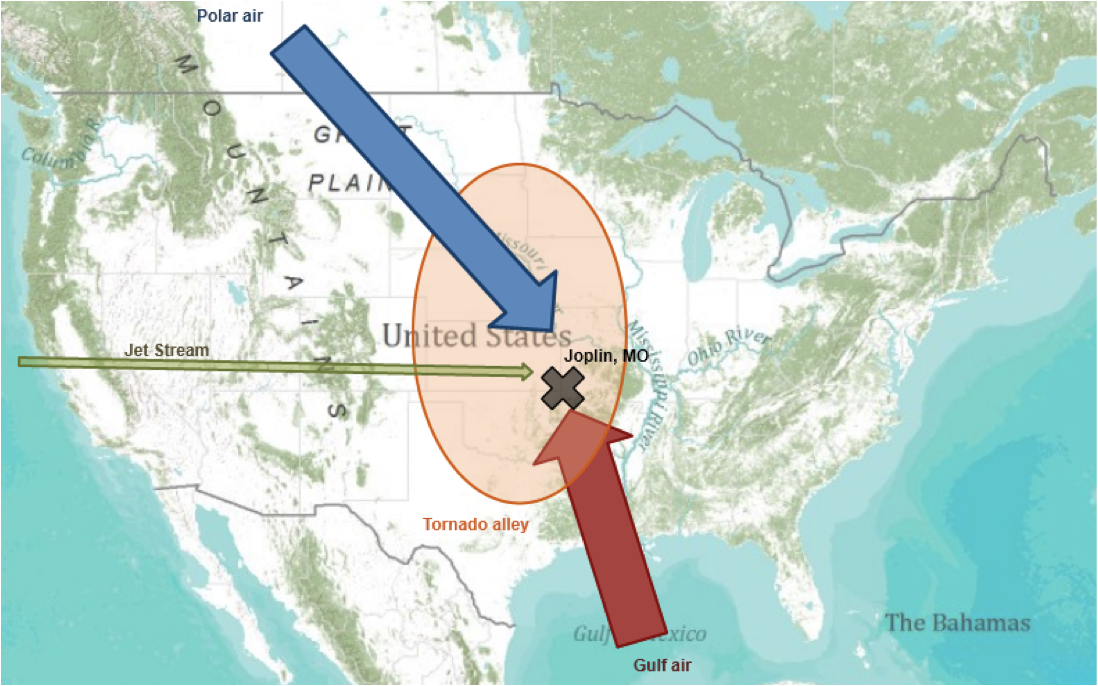
Weather conditions in "tornado alley" cause a high number of tornadoes yearly.
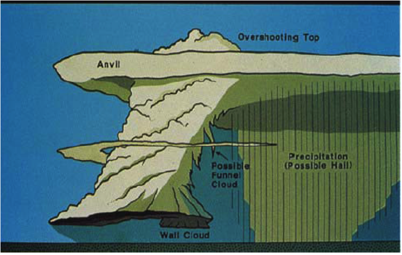
Anatomy of a supercell. Figure credit: Figure Credit: From C.A. Doswell III, A.R. Moller, and R. Przybylinski, 1990: A Unified Set of Conceptual Models for Variations on Supercell Theme. Preprints, 16th Conf. on Severe Local Storms, Kananaskis, Alta, Canada, 40-45.
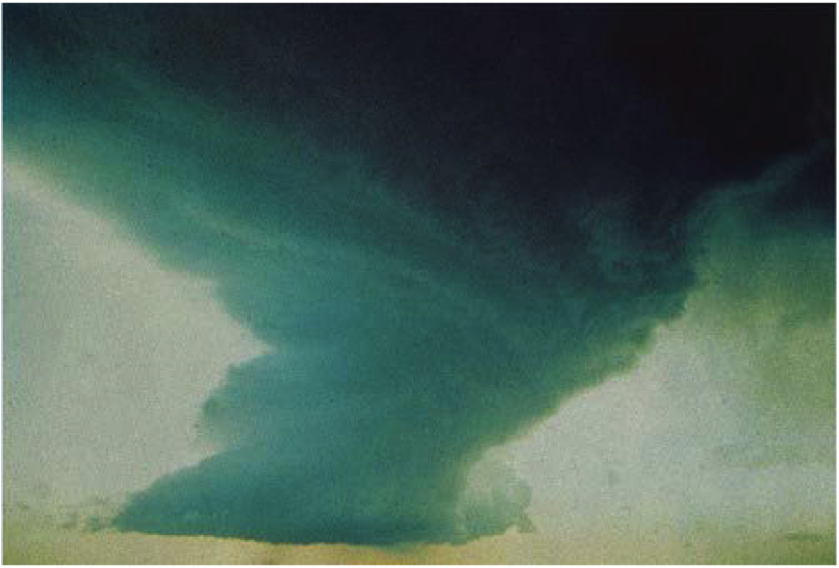
A supercell thunderstorm developing into a tornado. Photo credit: Steve Tegtmeier.
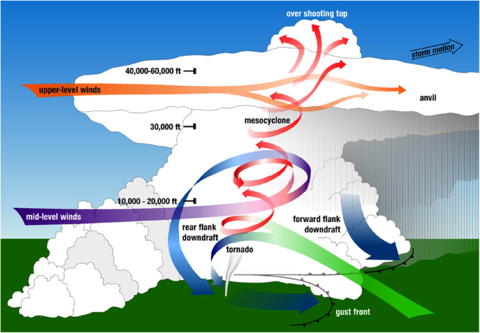
A diagram of the parts of a tornadic supercell, including a rear-flank downdraft. Figure credit:From the National Oceanic and Atmospheric Administration at http://www.nssl.noaa.gov/primer/torna do/tor_basics.html.
References:
Doswell, Moller, Anderson et al. (2005). "Advanced Spotters' Field Guide" Retrieved October 10, 2011 from the PD Department of Commerce website: http://www.nws.noaa.gov/os/brochures/adv_spotters.pdf
Edwards, R. (2011, October 5). The Online Tornado FAQ. Retrieved October 12, 2011, from National Oceanic and Atmospheric Administration's Storm Prediction Center website: http://www.spc.ncep.noaa.gov/faq/tornado/
Fabian, S. (n.d.). “How Does a Tornado Work?” Retrieved October 13, 2011, from edHelper website: http://teacherpages.nhcs.net/schools/anderson/lynneadams/Documents/How%2Does%20a%20Tornado%20Work.pdf
Gray, W. (2010, February 27). “Stormchaser: studying twisters up close”. New Scientist, pp. 40-43.
“Tornado: Development and Detection”, n.d. Retrieved October 18, 2011 from the National Weather Service Forecast Office website: http://www.erh.noaa.gov/cle/safety/svrwx_tornado.htmlhttp://www.erh.noaa.gov/cle/safety/svrwx_tornado.html
“Tornadoes: Natures Most Violent Storms.” Retried October 13, 2011 from the National Severe Storms Laboratory website: http://www.nssl.noaa.gov/edu/safety/ tornadoguide.html
